Tithes were originally a tax which required one-tenth of all agricultural produce to be paid annually to support the local church and clergy. After the Reformation much land passed from the Church to lay owners who inherited entitlement to receive tithes, along with the land.
By the early 19th century tithe payment in kind seemed a very out-of-date practice, while payment of tithes per se became unpopular, against a background of industrialisation, religious dissent and agricultural depression. The 1836 Tithe Commutation Act required tithes in kind to be converted to more convenient monetary payments called tithe rent-charge. The Tithe Survey was established to find out which areas were subject to tithes, who owned them, how much was payable and to whom.
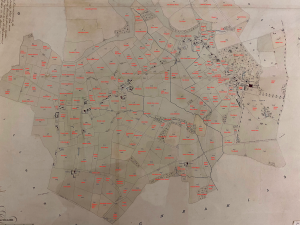
The tithe map and apportionment for Compton Bassett was carried out in the name of Thomas Tilbrook, a valuation officer, and his team of assistant tithe commissioners. The tithe apportionment is dated 27 October 1838 and the map was issued in 1839.
The map shows buildings, tithe ownership, field names, fence ownership, field gates, parkland, avenue of trees, woods, pit, osiers (withies), and waterbodies. Colouring used. Scale: 1 inch to 6 chains. By Phillips and Westbury, Andover.
The tithe apportionment was the main record of how tithes were to be commuted, showing how the overall rent-charge for the district was apportioned to individual landowners based on identifiable pieces of land, and how much tithe had to be paid for each plot of land. Details include names of owners and occupiers, size and use of plots of land.
The National Archives, Kew
Wiltshire & Swindon History Centre, Chippenham
Click on the arrow in the bottom left hand corner of the document to see pages 1 – 10.